Wednesday, July 24, 2013

Anglo-Saxon Chronicle Map, v 2.0

I recently had the pleasure of presenting my mapping project at SHARP's Digital Projects Showcase. I'm in the middle of writing a reflection/call-to-arms on my experience there, but wanted to share my materials sooner. So here they are: images from my handouts and the newest version of the map.
WHAT IS THE ANGLO-SAXON CHRONICLE?

A group of annalistic texts begun in the 9th century and, in one case, extending until the 12th.

It includes a variety of events: birth of Christ; natural and supernatural phenomena; royal births, coronations, deaths, and burials; consecrations; invasions; laws; property endowments; international and inter-family drama; the building (and burning) of towns.

A: the earliest surviving manuscript of the Chronicle; end date 1001; significant interest in Winchester
B: irregular annal numbers; end date 977; updated regnal list from A
C: “chronicle of chronicles” because of its sources; ends in the middle of 1066
D: integrates/conflates sources incorporated by C as one chunk; ends 1079; northern interest
E: longest chronicle version; end date 1154; begins in Old English and ends in Middle English
F: Bilingual
G: Copy of A
WHY MAP THE ANGLO-SAXON CHRONICLE?

In content alone, the Chronicle is an important part of early English history and literature (listory? histerature?) And unlike its contemporary chronicles on the European continent, it is uniquely vernacular. Some versions contain important regnal lists; some include poetry; they all tell a different story of England, documenting in varied narratives of the arrival of Brutus, Angles, Saxons, Vikings, Normans, missionaries, and bishops. Version D has the longest treatment of a woman in it, describing (and perhaps defending?) Margaret of Scotland’s marriage. The same version (D) actually ends mid-word in the annal entry for 1079; version C ends halfway through the entry for 1066—on the Stamford Bridge—and before the Battle of Hastings.
Although annals seem to be primarily focused on time, these are actually just as preoccupied by space. Indeed, location is so important to these texts that until recently, most were referred to as the chronicle of a place name: Winchester Chronicle, Abingdon Chronicle, Worcester Chronicle, and Peterborough Chronicle.  But these names didn’t only show the onomastic interest of the chronicles’ contents; they more accurately reflect the scholarly effort to trace their transmission history—multi-layered narrative.


TEACHING WITH THE CHRONICLE MAP


PROBLEMS WITH MAPPING?
There are plenty of issues surrounding the cartography of complex texts. Here are some that I dealt with in Google Earth: 
1) The map of Anglo-Saxon "England" changes over the course of these texts:


 2) The transmission histories are complicated, at best:
3) There are practical issues of data selection and entry when not all annals have traceable place-names:

So, 


But Google Maps Engine has just come out, and that's allowed me to sort and change displays. 

BEHOLD, THE ANGLO-SAXON CHRONICLE MAP 2.0!
It sorts data by date and label by event (or vice versa):
It layers multiple versions (10th century A and E shown here, labels hidden):
It allows me to build a database within the mapping program itself:
Still, there are some kinks to work out before I move forward. Consider, for example, what happens when I try to map regions like Wessex and Mercia:
It's not a pretty sight! Nevertheless, I've gotten great help from the UNC librarians and fellow SHARPists. More on both very, very soon.

Til then, 
Map on!

Monday, July 15, 2013

The newest Viking invasion


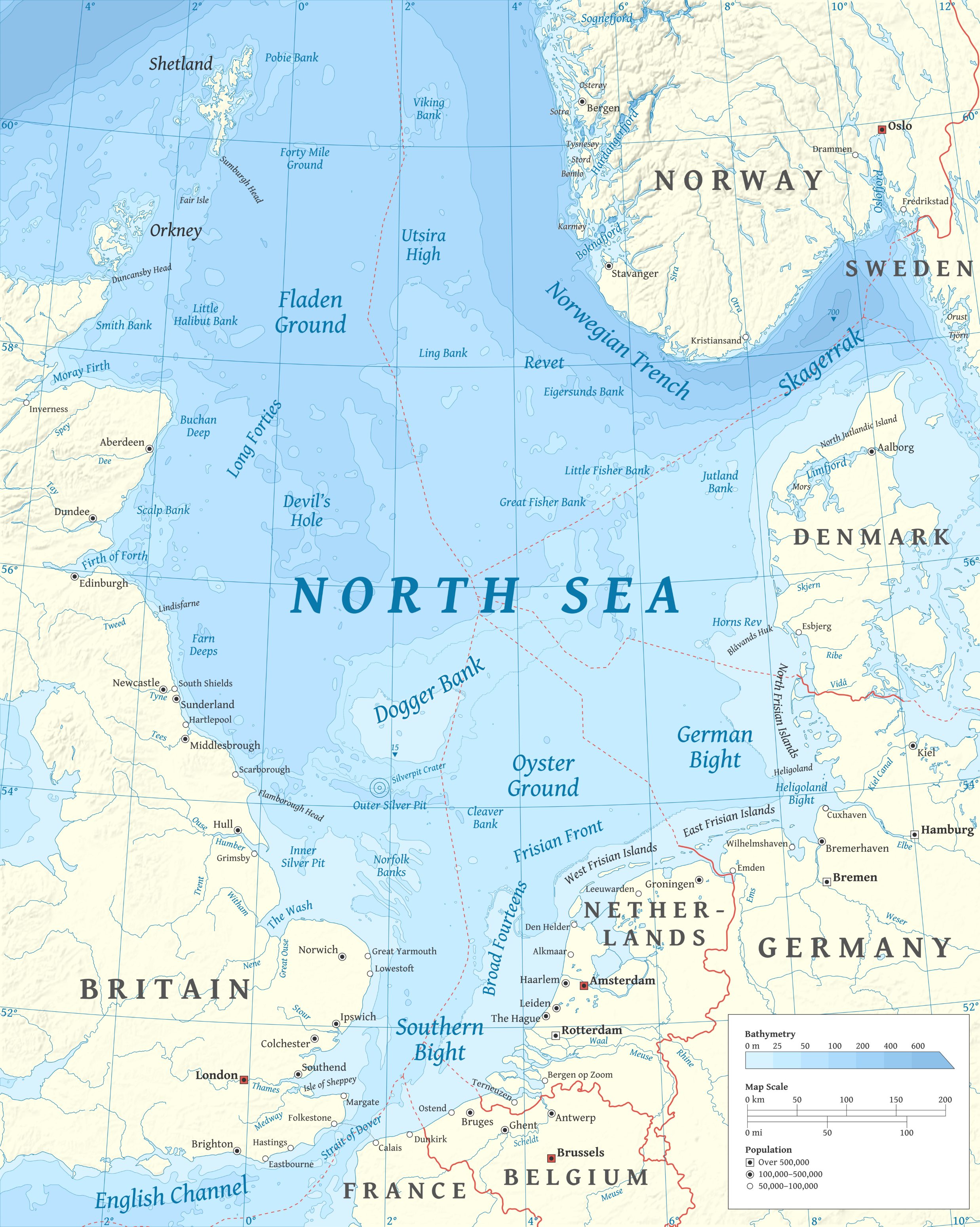
North_Sea_map-en.png
In my search for a dissertation topic (starting point: Anglo-Saxon prose), I am increasingly interested in exchanges among Anglo-Saxons and their North Sea neighbors.

I've recently been reading about spaces, places, and history (see my new Reading List page), but I keep being pulled by seafaring and its cultural impact on the region. So I started a new reading list, got on Amazon, and behold, the Vikings came straight to my door:
I stand by my tweet: "when vikings show up at your doorstep, let them in!"
My new line of inquiry comes as one of many in a series of summer novelties. Two different batches of baby birds hatched in our stoop; Drew graduated from law school (summa, 1st in his class, tons of awards); I've engaged in some small projects around the house. 

I also spent two weeks in London with librarians. My favorite firsts include seeing Stonehenge, the Alfred Stone, Oxford University Press, Bath, cave-crepes, and a tenth-century manuscript that I HELD WITH MY OWN TWO HANDS. 

After eleven straight weekends of travel, I was finally able to start my research in earnest. Once I realized that my interests were beginning to shift, I started with Haywood's Dark Age Naval Power and Unger's The Ship in the Medieval Economy, 600-1600.  Chapter 3, "Anglo-Saxon Piracy and the Migrations to Britain" was the most useful of Haywood's chapters to my research. It introduced me to the Litus Saxonicum, a series of Roman coastal defenses along both sides of the channel. 
Litus Saxonicum, Wikimedia Commons
If only I'd picked this book up a few months earlier! I've missed the submission deadline for BABEL's 2014 "On the Coast"meeting in Santa Barbara, but I'm encouraged that shoreline studies are now on the cutting-edge (HA. get it? edge?).
http://en.wikipedia.org/wiki/File:Anglo.Saxon.migration.5th.cen.jpg

Aaaaanyway, after the Romans withdrew from Britain in 410, Saxon raids increased. A note on vocabulary here-- at this point in the story, no one's a Viking yet.
Britons were native to the island; Angles, Saxons, Jutes, and Frisians were invaders. 

According to Haywood, archeological evidence suggests that the Anglo-Saxon settlements came in two waves: "the first began in the early fifth century and was confined mainly to eastern Britain and was confined mainly to eastern Britain between the Humber and the Thames"and the second, spanning the middle of the fifth century and the start of the sixth,  included "Kent and the south coast" as well as "the Midlands from East Anglia" (80).


 Haywood reads in the Anglo-Saxon Chronicle that, "the Anglo-Saxons who came to Britain after the mid-fifth century, such as Cerdic in Wessex or Aelle in Sussex, did not arive as either pirates or federates but as seaborne conquerors" (83). If those names seem at all familiar (and you're not a medievalist), that's totally legit. Here's where you've heard them before: Cerdic is portrayed the previously blogged-about King Arthur (left). King Aelle(a) is a character on the TOTALLY AWESOME History Channel series, Vikings (right).

Ok, so, back to the scholarship. After briefly discussing the literary accounts of the 5th century invasions (Gildas, Bede, Gallic Chronicles, Anglo-Saxon Chronicles), Haywood reminds us that the Saxon raiders did not limit themselves to Briton--they raided in Gaul as late as the seventh century (though by now they're starting from Britain as opposed to Saxony). Next he goes through the development of shipbuilding by the Angles and Saxons, showing that "by the second half of the seventh century we can be quite certain that the sail was in everyday use by the Anglo-Saxons" (107).  Note his use of Anglo-Saxon here. By now, this can refer to Angles and Saxons living in Britain. 

You're rightly wondering, "where the ___ are the Vikings in this damn post?" Never fear, readers--they arrive just when you don't expect them [kidding; see below].

The beginning of the Viking Age is marked by most at 789, when Scandinavians came to Portland and were mistakenly identified as merchants by an ill-fated reeve. The reason I included all this background is because in a grossly-over-simplified version of reality, the Vikings did to the Anglo-Saxons what the Angles and Saxons had done to the Britons. Just as Angles and Saxons came to Britain in raiding parties and eventually settled, so the Vikings (mostly Norse and Danish) arrived-- at first as pillagers and then, as we can see from place-names, genealogies, genetics, archaeology, history, laws, and literature, as settlers in increasingly important ports. In case you've fallen into the "meh, I don't really care about that" trap, check out McGlashan's 2003 article about the Vikings' generous beach laws, which I found in a perfectly-timed tweet by Medievalists.net.

Despite Haywood's detailed coverage of pre-Viking shipbuilding, Unger's analysis of shipbuilding technology and its economic impact in his chapter on "Vikings and Byzantines: 750-1000" is surprisingly engaging (and I think better researched). Unger traces the development of vessels within the context of technological, military, and economic changes. He shows us that "[t]he development of the Viking ship was the most important change in European ship design from 750 to 1000"because it  "marked a significant improvement in the ability to move people" (Unger, 80-81). And these people, in turn, went south to Iberia and through the Mediterranean to Alexandria; east to the Black and Caspian Seas; and west to Iceland, Greenland, and Canada. The new Viking ships were stable, deep-seaworthy, and light enough to carry on small stretches of land (82). And how do we know this? Because we still have some. 

You can see a few at Oslo's Viking Ship Museum, whose gift shop boasts such gems as Terry Jones's children's book and slides of the exhibits. SLIDES. 
"Wait, what are these?" And yes, it is THAT cold inside Norwegian museums in December
And the Viking warships weren't their only vessels to reflect and affect social, political, and economic change. Here's my last bit from Unger (for now):
The result of Viking voyages was to extend the realm of northern trade, to promote the full integration of Scandinavia into a northern trading network and to intensify trade within that network. The emergence of Europe about the year 1000 from the difficulties, political and economic, of the preceding 150 years was certainly a result of the end of raids by Vikings in their warships. But t was also a result of the ability of Scandinavians to turn their new type of vessel to commercial advantage. (94)
So you see, Vikings were able to conquer and settle; they drew new boundaries on land and carved new "whale-roads" at sea. Awesome, am I right?

My next book to read (and already the prologue was hard to put down) is Studies in the Medieval Atlantic, whose image I posted yesterday to facebook and Instagram. I hope to include it in a shorter post soon, but I'll leave that for another day when I can give it the attention and space it deserves. 

Until next time, wishing everyone the blessings of newness (and no threats of invasion).


Works cited: 
Haywood, John. Dark Age Naval Power: A Reassessment of Frankish and Anglo-Saxon Seafaring Activity. Routledge, 1999.
Unger, Richard W. The Ship in Medieval Economy 600-1600. London, 1980.

Sunday, July 7, 2013

New page! My reading list

Hello again, readers!
To supplement the Taxonomic Chart of Medieval Research Tools and more general Academic Sources, I've added my personal reading list and goals for the summer on a new page, under the oh-so-spicy title of Reading List. I will revisit this page as my list grows, and if feeling particularly ambitious or moved, will update it with short synopses or judgments. Let me know what you think, or if you have recommendations or requests.
Til soon,
Wishing everyone some bibliographic bliss.